Chernobyl, the area of land which was contaminated by the radioactive explosion of the Chernobyl nuclear power plant in 1986, is now greatly overgrown. Now, as a tourist destination, the area receives up to 10,000 tourists each year and within such a vast amount of land it’s not always easy for tourists to visualise the terrain.
Before visitors travel to Chernobyl and Pripyat, it would be a good idea to study maps or satellite imagery of the area. Chernobyl maps can be used to pinpoint buildings and locations of interest, making it easier to understand the layout once in the zone.
Satellite Views of Chernobyl

Systems such as Google Earth can give you a great in-depth view of the landscape of Chernobyl, before your Chernobyl Tour. Viewing satellite imagery will identify the areas, buildings, streets, factories, sports complexes and more, but without local knowledge it may still be hard to decipher what is what.
Google Earth identifies some places of interest within the zone; for example, Hotel Polesie in Pripyat is marked as a hotel and the Chernobyl Nuclear Power Plant is easily identifiable by another location marker. Looking deeper at the imagery, it’s also easy to see the Pripyat Ferris wheel and its shadow; its yellow carts make it a beacon of colour in an otherwise grey city.
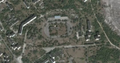
By the Ferris wheel, the Palace of Culture is an obvious landmark to recognize. Its curved, framed architecture and a large, open concrete area to the south-east of the building identify this sight as the centre of Pripyat. From here many other famous landmarks can be seen; using the Palace as a starting point you can see the tallest building in Pripyat towards the south-west. Moving towards the north-east and passing the Ferris wheel, you can clearly see the marked out track for the athletes of the Football Stadium. While viewing this from the ground, you will only see a broken building with some trees.
Travelling north-east of the Palace of Culture, you will discover a lake with an observation deck on the south-west side. Viewing from the ground at this location will give you an excellent image of the house-boat; though, viewing from a satellite image clearly shows that the boat has been moored at the south side of the lake and against a piece of land.
Maps of Chernobyl
ChernobylX have prepared 2 maps of the Chernobyl area where all landmarks have been clearly identified using colourful icons. You can download the PDF maps at the bottom of the tour pages of our tours or you can find more maps on CHERNOBYLMAPS.COM.
Author: Jimmy Ryan